
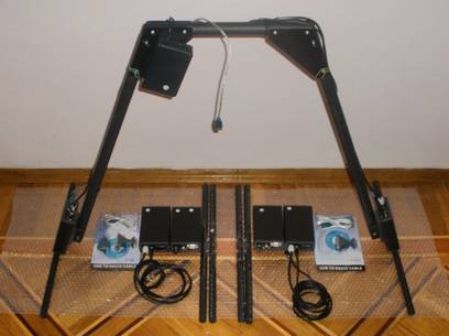
Uses : EasyRad GPR 20Mhz-400Mhz
-
 Search Depth-
 -
 Country of Origin-
 -
 Factory-
 -
guarantee-
GIS services.
Engineering-geological problems with the possibility of measuring not only on the surfaces of soil, buildings, installations, but also on board of air vehicles, ice and water.
Nondestructive diagnostic testing of the soil condition beneath the surface of urban areas, industrial sites and separate unique installations (evaluation of moisture of layers, detection and mapping of distribution of leakage water zones, assessment of flooding, detection of voids and the soil decompression).
- Assessment of the condition of the subsurface structure of subsoil of dams, embankments, coast defenses, quays (evaluation of the moisture level of the soil layers, the degree of decompression).
- Control over the condition of road surfaces, soil and fill under railway bed.
- Assessment and diagnostic testing of the subsurface structure and the soil condition of landslides, mapping of the areas of their distribution as well as evaluation of their sustainability.
- Mapping of contaminated soil, landfills of industrial and household wastes.
- Mapping of the areas of distribution of liquid petroleum products (lenses) as a result of unauthorized leaks and accidents beneath the surface of industrial and technology-related areas.
- Mapping of underground communication facilities (cables, pipelines and other underground facilities).
- Identification of condition of foundations and building structure of existing installations.
- Detection of non-homogeneity of the subsurface structure of soil, associated with archeological artifacts.
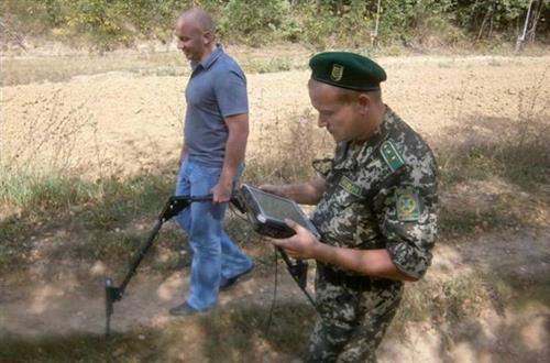
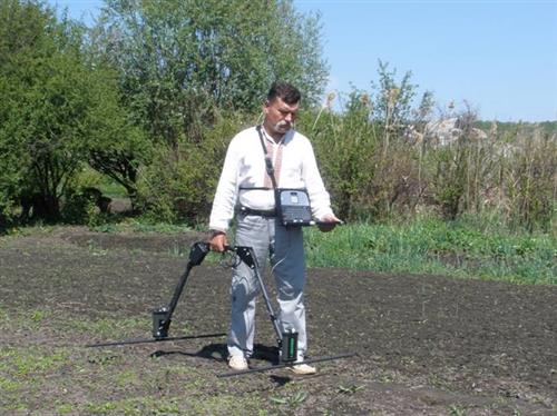
- Area survey during field engineering and search and rescue operations.
- Survey of water areas (identification of depth and profile of the bottom of rivers and lakes, thickness of the ice and snow, detection of submerged objects).
- Search and identification of any metal and non-metal purposes, voids.
- Delivery of the equipment complexes for subsurface probing: ground penetrating radars, magnetometers, gradiometers, anomaly detectors, electro/magnetic scanners, IR imagers, specialized metal detectors.
- Staff training, consulting. Individual courses for training the GIS operators.
- Areas of application.
- Engineering.
- Mapping and Localization of:
- gaps and defects in structure;
- thickness of the coating, foundation, etc.;
- valves, columns and other bearing structures;
- thinning, deformation and other types of damage of coating, foundation, etc.;
built-in units components and systems in constructions and structures.
- Nondestructive research, assessment and monitoring of coatings, platforms, foundations, slabs, retaining and supporting structures as well as other structures.
- 2. Communications.
- Mapping and Localization of:
- buried and walled pipes, cables, channels, tunnels, etc.;
- underwater pipes, cables, tunnels, etc.;
-
efflux in pipes (water, gas, etc.).
- Nondestructive research, assessment and monitoring of all kinds of communication.
- 3. Transportation.
- Mapping and Localization of:
- cracks, dip of earth masses, voids and other defects in the base and coating of roads, highways, railway tracks and other installations;
- cracks, dip of earth masses and other defects in tunnels and tunnel constructions;
- tinning, deformations, cracks, voids and other defects in bridges and bridge constructions.
- Nondestructive research, assessment and monitoring of roads, highways, railway tracks, tunnels, bridges and other structures.
- 4. Environment.
- Mapping and Localization of:
- leaks, spills and other pollutants spread;
- buried, concreted and underwater hazardous wastes;
- underground storage tanks of pollutants; protected natural sites.
- Nondestructive research, assessment and monitoring of condition of polluted areas, groundwater, reservoirs, storage of hazardous wastes and protected natural sites.
- 5. Geotechnological.
- Mapping of:
- bedrock;
- sediments
- underwater sediments;
- soils;
- aquifers;
- bottom of lakes and rivers;
- karsts formations (cavities, etc.);
- gatherings of earth masses, landslides.
- Research, assessment and monitoring of geological and hydrological conditions.
- 6. Mining.
- Mapping and Localization of:
- coal layers;
- gold diggings;
- salt pans;
- deposits of bauxites
- hazardous areas in open pit mines and mine galleries.
- Research, assessment and monitoring of miming and hazardous areas.
- 7. Military. Search and Rescue.
- Mapping and Localization of:
- cables, pipelines, tunnels, communication; caverns, caves, bunkers, etc.;
- anti-personnel and anti-tank mines;
- unexploded shell
- defects in roads, highways, bridges, tunnels, bunkers, landfills, etc.;
- scarps and counterscarps.
- 8. Archeological.
- Mapping and Localization of:
- cultural layers and archeological objects;
- graves, tombs, tunnels, walls, foundations, furnaces and other artifacts.
- 9. Judicial.
- Mapping and Localization of:
- single and mass graves;
- buries, concreted or otherwise hidden weapons, ammunition supplies, hazardous substances, etc
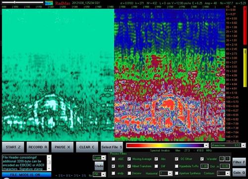
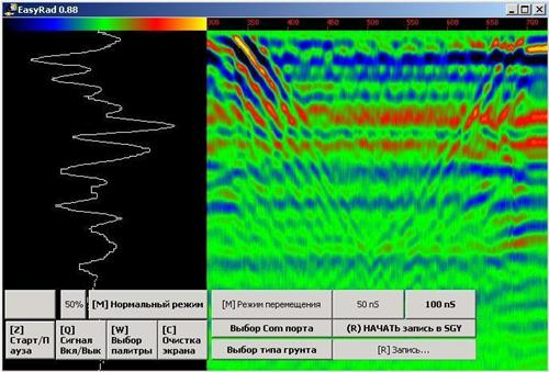
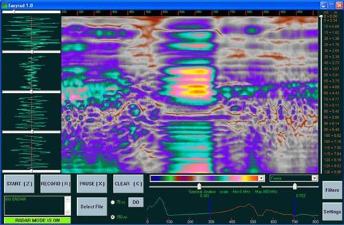
- Some of the results obtained with the aid of the ground penetrating radar of the sub-surface probing.